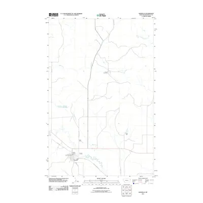
2011 Map of Bainville
USGS Topo · Published 2011About this map
Bainville stands as a focal point of Roosevelt County in this modern survey, revealing the infrastructure of a settled agricultural community. The town's grid is anchored by essential civic landmarks including the Bainville Post Office and the Bainville Rural Fire Dist, while the nearby Bainville Cemetery provides a primary point of interest for those tracing local family lineage. The surrounding landscape is defined by its water management systems, characterized by numerous small impoundments such as Feisty Dam, Wilde Dam, and Crusch Pond Dam. These structures, along with the meandering paths of Snake Creek and Shotgun Creek, illustrate the historical and ongoing efforts to harness water in this plains environment. A network of local roads, from the central 5th Ave to the Bainville-Snowden Rd, connects the town center to the outlying reservoir at Shotgun Reservoir, marking the enduring transport and irrigation patterns of the region.
Find a feature on this map
18 named features on this map. Tap any name to fly to it.
Don’t see what you’re looking for? This feature index may not catch every label — zoom into the map to look around manually.
Map Details
Editions of this 2011 Bainville Map
This is the sole edition of this map. No revisions or reprints were ever made.
Other maps of this area

1954 · Wolf Point
USGS Topo · 1:250,000

1958 · Wolf Point
USGS Topo · 1:250,000

1968 · Bainville SE
USGS Topo · 1:24,000

1969 · Cedar Coulee
USGS Topo · 1:24,000

1969 · Bainville SW
USGS Topo · 1:24,000

1974 · Red Bank Creek
USGS Topo · 1:24,000
1974 · Bull Butte
USGS Topo · 1:24,000

1982 · Culbertson
USGS Topo · 1:100,000
1983 · Bainville
USGS Topo · 1:24,000
1983 · Brush Mountain SW
USGS Topo · 1:24,000