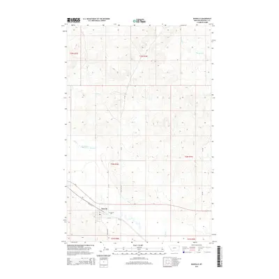
2014 Map of Bainville
USGS Topo · Published 2014About this map
Bainville serves as the primary hub in this eastern Montana landscape, situated along the corridor formed by Us-2 and Highway Ave. The town's grid is anchored by 5th Ave and includes a local Po, while the Bainville Cem lies just to the east. The surrounding terrain is defined by a network of drainage systems, including the southward-flowing Snake Cr, Shotgun Cr, and Red Bank Cr in the northeast. This 2014 survey illustrates the intersection of local rural transit and regional infrastructure, with Snake Butte Rd and S Bainville Rd connecting the township to the higher elevations and coulees of the Roosevelt County plains. The map's detailed topography reveals the complex undulations of the Missouri River plateau just north of the river's main valley.
Find a feature on this map
20 named features on this map. Tap any name to fly to it.
Don’t see what you’re looking for? This feature index may not catch every label — zoom into the map to look around manually.
Map Details
Editions of this 2014 Bainville Map
This is the sole edition of this map. No revisions or reprints were ever made.
Other maps of this area

1954 · Wolf Point
USGS Topo · 1:250,000

1958 · Wolf Point
USGS Topo · 1:250,000

1968 · Bainville SE
USGS Topo · 1:24,000

1969 · Cedar Coulee
USGS Topo · 1:24,000

1969 · Bainville SW
USGS Topo · 1:24,000

1974 · Red Bank Creek
USGS Topo · 1:24,000
1974 · Bull Butte
USGS Topo · 1:24,000

1982 · Culbertson
USGS Topo · 1:100,000
1983 · Bainville
USGS Topo · 1:24,000
1983 · Brush Mountain SW
USGS Topo · 1:24,000