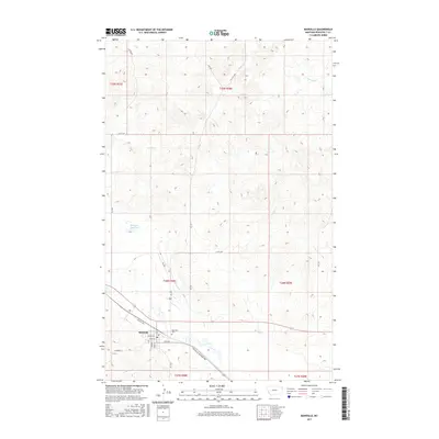
2017 Map of Bainville
USGS Topo · Published 2017About this map
Bainville serves as the primary hub in this corner of Roosevelt County, where a structured grid of residential streets like Tubman St and Clark Ave meets the open agricultural landscape of northeastern Montana. The town’s social and geographic center is clearly defined by local thoroughfares such as Highway Ave and the Bainville-Snowden Rd, which provides a vital link to the surrounding rural sections. North of the settlement, the Bainville Cem offers a point of interest for genealogists tracing families in the region. The landscape is carved by several ephemeral and persistent waterways, including Snake Cr, Red Bank Cr, and Shotgun Cr, alongside the Shotgun Reservoir. These features, along with numerous county roads like Co Rd 2057, illustrate the intersection of early 21st-century infrastructure with the prairie's natural drainage patterns.
Find a feature on this map
29 named features on this map. Tap any name to fly to it.
Don’t see what you’re looking for? This feature index may not catch every label — zoom into the map to look around manually.
Map Details
Editions of this 2017 Bainville Map
This is the sole edition of this map. No revisions or reprints were ever made.
Other maps of this area

1954 · Wolf Point
USGS Topo · 1:250,000

1958 · Wolf Point
USGS Topo · 1:250,000

1968 · Bainville SE
USGS Topo · 1:24,000

1969 · Cedar Coulee
USGS Topo · 1:24,000

1969 · Bainville SW
USGS Topo · 1:24,000

1974 · Red Bank Creek
USGS Topo · 1:24,000
1974 · Bull Butte
USGS Topo · 1:24,000

1982 · Culbertson
USGS Topo · 1:100,000
1983 · Bainville
USGS Topo · 1:24,000
1983 · Brush Mountain SW
USGS Topo · 1:24,000