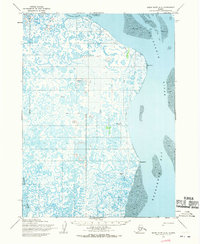
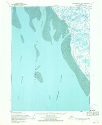
1954 Map of Baird Inlet A-2
USGS Topo · Published 1970About this map
Kuskokwim River and the sweeping tidal marshes of southwest Alaska dominate this mid-century survey. The landscape is defined by an intricate network of water and wetlands, where the Tagayarak River feeds into the broad delta. Traditional land use and seasonal movements are evidenced by the Winter Trail cutting across the northern reaches and named locations like Bivouac and Snooks. Settlement patterns along the eastern shoreline show established sites such as Popokamiut, while interior locations like Kuskovak and Papka are noted specifically as sites, reflecting the changing nature of habitation in the Yukon-Kuskokwim Delta. To the south, the Ishkowik River meanders toward Kuskokwim Bay, illustrating the complex hydrology of this coastal environment near West Point.
Find a feature on this map
12 named features on this map. Tap any name to fly to it.
Don’t see what you’re looking for? This feature index may not catch every label — zoom into the map to look around manually.
Map Details
Editions of this 1954 Baird Inlet A-2 Map
2 editions found
Other maps of this area

1951 · Kuskokwim Bay
USGS Topo · 1:250,000

1951 · Baird Inlet
USGS Topo · 1:250,000
1953 · Kuskokwim Bay D-2
USGS Topo · 1:63,360

1954 · Baird Inlet A-3
USGS Topo · 1:63,360

1954 · Baird Inlet
USGS Topo · 1:250,000

1954 · Kuskokwim Bay
USGS Topo · 1:250,000

1954 · Baird Inlet B-1
USGS Topo · 1:63,360
1954 · Baird Inlet A-1
USGS Topo · 1:63,360
1954 · Kuskokwim Bay D-1
USGS Topo · 1:63,360

1954 · Baird Inlet B-3
USGS Topo · 1:63,360