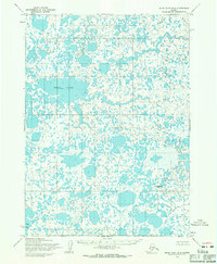
1954 Map of Baird Inlet B-4
USGS Topo · Published 1971About this map
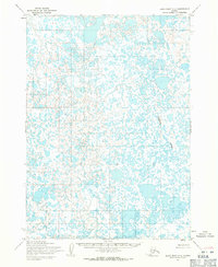
Dall Lake dominates this mid-century survey of the Alaskan interior, appearing as a massive water body amidst an intricate, waterlogged landscape. Located in the Baird Inlet region, the terrain is characterized by thousands of small, unnamed ponds and wetlands that create a complex mosaic of land and water. The Chukwugwahlik River winds through the northern portion of the sheet, providing one of the few named navigational corridors in an area otherwise devoid of roads or trails. Human presence is remarkably sparse, centered on the Kowilikulik (Site) and a secondary label for Dall Lake. This map represents the region as documented through aerial photography in the early 1950s, capturing a remote wilderness before significant modern infrastructure reached these wetlands.
Find a feature on this map
5 named features on this map. Tap any name to fly to it.
Don’t see what you’re looking for? This feature index may not catch every label — zoom into the map to look around manually.
Map Details
Editions of this 1954 Baird Inlet B-4 Map
This is the sole edition of this map. No revisions or reprints were ever made.
Other maps of this area

1951 · Baird Inlet
USGS Topo · 1:250,000
1953 · Baird Inlet C-5
USGS Topo · 1:63,360

1953 · Baird Inlet B-5
USGS Topo · 1:63,360
1954 · Baird Inlet A-5
USGS Topo · 1:63,360

1954 · Baird Inlet A-3
USGS Topo · 1:63,360

1954 · Baird Inlet
USGS Topo · 1:250,000
1954 · Baird Inlet C-4
USGS Topo · 1:63,360
1954 · Baird Inlet C-3
USGS Topo · 1:63,360

1954 · Baird Inlet B-3
USGS Topo · 1:63,360
1954 · Baird Inlet A-4
USGS Topo · 1:63,360