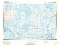
1954 Map of Baird Inlet
USGS Topo · Published 1978About this map
Baird Inlet and the vast Kuskokwim River delta dominate this mid-century landscape of western Alaska. The area is defined by a complex network of tundra ponds and tidal waterways within the Clarence Rhode National Wildlife Range. Settlements such as Newtok and Chefornak anchor the coastal and riverine regions, while numerous locations like Nunakauiak and Chiloghunut are identified as former sites, preserving the footprint of historical habitation patterns.
Find a feature on this map
94 named features on this map. Tap any name to fly to it.
Don’t see what you’re looking for? This feature index may not catch every label — zoom into the map to look around manually.
Map Details
Editions of this 1954 Baird Inlet Map
3 editions found

Other maps of this area

1947 · Russian Mission
USGS Topo · 1:250,000

1950 · Russian Mission
USGS Topo · 1:250,000

1950 · Bethel
USGS Topo · 1:250,000

1951 · Marshall
USGS Topo · 1:250,000

1951 · Kuskokwim Bay
USGS Topo · 1:250,000

1951 · Hooper Bay
USGS Topo · 1:250,000

1951 · Cape Mendenhall
USGS Topo · 1:250,000

1951 · Nunivak Island
USGS Topo · 1:250,000

1951 · Goodnews
USGS Topo · 1:250,000

1951 · Baird Inlet
USGS Topo · 1:250,000