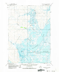
1954 Map of Baird Inlet C-7
USGS Topo · Published 1973About this map
Nelson Island and the complex waterways of the Yukon-Kuskokwim Delta dominate this mid-century survey. The landscape is defined by a dense network of tidal sloughs and rivers, including the broad Kolavinarak River and the Kinaruk River, which weave through the Clarence Rhode National Wildlife Range Area No 2. This area represents a critical arctic wetland ecosystem as it was documented in the early 1950s, featuring landmarks like Emperor Island and the Nyctea Hills.
Find a feature on this map
20 named features on this map. Tap any name to fly to it.
Don’t see what you’re looking for? This feature index may not catch every label — zoom into the map to look around manually.
Map Details
Editions of this 1954 Baird Inlet C-7 Map
3 editions found
Other maps of this area

1951 · Baird Inlet
USGS Topo · 1:250,000
1953 · Baird Inlet C-6
USGS Topo · 1:63,360

1954 · Baird Inlet D-6
USGS Topo · 1:63,360

1954 · Baird Inlet C-7
USGS Topo · 1:63,360

1954 · Baird Inlet D-7
USGS Topo · 1:63,360

1954 · Baird Inlet
USGS Topo · 1:250,000

1954 · Baird Inlet B-6
USGS Topo · 1:63,360

1954 · Baird Inlet B-7
USGS Topo · 1:63,360

1954 · Baird Inlet C-8
USGS Topo · 1:63,360

1954 · Baird Inlet D-8
USGS Topo · 1:63,360