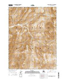
2015 Map of Baird Mountains C-6 NE
USGS Topo · Published 2015About this map
Noatak National Preserve encompasses the southern portion of this topographic survey, protecting a landscape where natural drainage patterns dictate the rhythm of the wilderness. The Eli River enters the frame in the northeast and cuts westward across the terrain, serving as the primary hydrological artery for this section of the Baird Mountains. The map provides a precise layout of the Public Land Survey System, showing the intersection of townships t27n r14w, t27n r13w, t26n r14w, and t26n r13w. These boundaries, alongside the detailed contour lines, reveal the complex elevation changes and drainages that characterize this protected Arctic environment in the mid-2010s.
Find a feature on this map
6 named features on this map. Tap any name to fly to it.
Don’t see what you’re looking for? This feature index may not catch every label — zoom into the map to look around manually.
Map Details
Editions of this 2015 Baird Mountains C-6 NE Map
This is the sole edition of this map. No revisions or reprints were ever made.
Other maps of this area

1951 · Baird Mountains
USGS Topo · 1:250,000

1955 · Baird Mountains D-6
USGS Topo · 1:63,360

1955 · Baird Mountains D-5
USGS Topo · 1:63,360
1955 · Baird Mountains C-5
USGS Topo · 1:63,360
1955 · Baird Mountains C-6
USGS Topo · 1:63,360

1956 · Baird Mountains
USGS Topo · 1:250,000

1965 · Baird Mountains
USGS Topo · 1:250,000
2015 · Baird Mountains D-5 SW
USGS Topo · 1:25,000
2015 · Baird Mountains D-6 SE
USGS Topo · 1:25,000
2015 · Baird Mountains C-5 SW
USGS Topo · 1:25,000