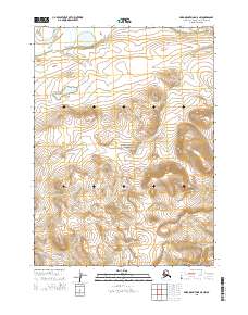
2015 Map of Baird Mountains D-5 NW
USGS Topo · Published 2015About this map
Noatak National Preserve encompasses most of this landscape within the Baird Mountains, showing the complex hydrology and elevation of the Alaska-Northwest Arctic Borough. The broad Noatak River dominates the northwest corner of the sheet, serving as a primary drainage for the surrounding highlands. South of the main river, several significant waterways including Maiyumerak Cr and Kivivik Cr cut through the terrain, illustrating the natural drainage patterns that have shaped this wilderness. In the southeast, Porgo Cr flows through the area defined by the T29N R11W boundary. The absence of roads or permanent settlements emphasizes the protected status of this region, where the terrain is governed by the shifting courses of mountain creeks and the preservation of the vast Noatak watershed.
Find a feature on this map
9 named features on this map. Tap any name to fly to it.
Don’t see what you’re looking for? This feature index may not catch every label — zoom into the map to look around manually.
Map Details
Editions of this 2015 Baird Mountains D-5 NW Map
This is the sole edition of this map. No revisions or reprints were ever made.
Other maps of this area

1951 · Baird Mountains
USGS Topo · 1:250,000

1951 · Misheguk Mountain
USGS Topo · 1:250,000

1955 · Baird Mountains D-6
USGS Topo · 1:63,360

1955 · Baird Mountains D-5
USGS Topo · 1:63,360

1955 · Misheguk Mountain A-5
USGS Topo · 1:63,360
1955 · Misheguk Mountain A-4
USGS Topo · 1:63,360

1956 · Misheguk Mountain
USGS Topo · 1:250,000

1956 · Baird Mountains
USGS Topo · 1:250,000

1965 · Baird Mountains
USGS Topo · 1:250,000
2015 · Misheguk Mountain A-5 SE
USGS Topo · 1:25,000