
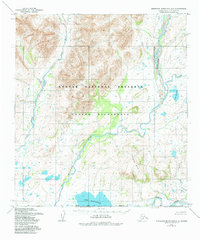
1955 Map of Misheguk Mountain A-5
USGS Topo · Published 1967About this map
The Noatak River corridor and its surrounding glacial lake systems define this 1955 survey of the Northwest Arctic region. Large water bodies like Lake Narvakrak and Lake Kaiyak dominate the lower elevations, while the braided paths of the Kugururok River and Avan River cut through the landscape, revealing the complex drainage patterns of this high-latitude environment. The mapping, conducted by the Army Map Service, details the topographical transition between the Uchugrak Hills and the river basins.
Find a feature on this map
8 named features on this map. Tap any name to fly to it.
Don’t see what you’re looking for? This feature index may not catch every label — zoom into the map to look around manually.
Map Details
Editions of this 1955 Misheguk Mountain A-5 Map
2 editions found
Other maps of this area

1951 · De Long Mountains
USGS Topo · 1:250,000

1951 · Baird Mountains
USGS Topo · 1:250,000

1951 · Noatak
USGS Topo · 1:250,000

1951 · Misheguk Mountain
USGS Topo · 1:250,000

1955 · Noatak
USGS Topo · 1:250,000

1955 · De Long Mountains
USGS Topo · 1:250,000

1955 · Noatak D-1
USGS Topo · 1:63,360

1955 · Baird Mountains D-6
USGS Topo · 1:63,360

1955 · Baird Mountains D-5
USGS Topo · 1:63,360

1955 · De Long Mountains A-1
USGS Topo · 1:63,360