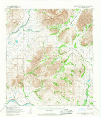
1955 Map of Misheguk Mountain A-4
USGS Topo · Published 1967About this map
The Noatak River serves as the primary drainage for this remote landscape in Northwest Arctic, Alaska, as mapped by the Army Map Service in the mid-1950s. The topography is dominated by the massive Poktovik Mountains and the northern reaches of Misheguk Mountain, where sharp elevation changes are traced by a dense network of high-altitude drainages. In this era, the only evidence of overland passage is a single marked Trail that cuts through the northwestern corner, following the path of Okotak Creek. This map captures a strictly natural landscape before modern infrastructure reached the interior, focusing on the complex relationship between the glaciated peaks like Puutik Mountain and the watercourses that feed the larger river systems. Tributaries such as Kaluktavik River and Analak Creek wind through deep valleys, providing a precise record of the regional hydrology and terrain that defined the territory during the 1950s.
Find a feature on this map
10 named features on this map. Tap any name to fly to it.
Don’t see what you’re looking for? This feature index may not catch every label — zoom into the map to look around manually.
Map Details
Editions of this 1955 Misheguk Mountain A-4 Map
2 editions found
Other maps of this area

1951 · Baird Mountains
USGS Topo · 1:250,000

1951 · Misheguk Mountain
USGS Topo · 1:250,000

1955 · Baird Mountains D-4
USGS Topo · 1:63,360

1955 · Baird Mountains D-5
USGS Topo · 1:63,360

1955 · Misheguk Mountain A-3
USGS Topo · 1:63,360

1955 · Misheguk Mountain A-5
USGS Topo · 1:63,360

1956 · Misheguk Mountain
USGS Topo · 1:250,000

1956 · Baird Mountains
USGS Topo · 1:250,000

1965 · Baird Mountains
USGS Topo · 1:250,000
1990 · Misheguk Mountain B-5
USGS Topo · 1:63,360