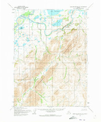
1955 Map of Baird Mountains D-6
USGS Topo · Published 1973About this map
The Noatak River dominates the northern reaches of this mid-century survey, winding through a landscape of expansive riverbeds and arctic lakes. In this remote territory, the Kugurukok River joins the Noatak from the north, marking a significant confluence just west of Lake Narvakrak. The terrain is defined by the massive uplift of the Baird Mountains and the Maiyumerak Mountains, which create a complex system of drainages including Kungiakrok Creek and Ahaliknak Creek. A notable geological feature is the Sekuiak Canyon, where the Noatak cuts through the high ground beneath a prominent Bluff. This map represents the area before any modern infrastructure was established, showing the natural state of water bodies like Lake Tulugak and Lake Mapsa in a period of early aerial photogrammetric mapping.
Find a feature on this map
15 named features on this map. Tap any name to fly to it.
Don’t see what you’re looking for? This feature index may not catch every label — zoom into the map to look around manually.
Map Details
Editions of this 1955 Baird Mountains D-6 Map
2 editions found
Other maps of this area

1951 · De Long Mountains
USGS Topo · 1:250,000

1951 · Baird Mountains
USGS Topo · 1:250,000

1951 · Noatak
USGS Topo · 1:250,000

1951 · Misheguk Mountain
USGS Topo · 1:250,000

1955 · Noatak
USGS Topo · 1:250,000

1955 · De Long Mountains
USGS Topo · 1:250,000

1955 · Noatak D-1
USGS Topo · 1:63,360

1955 · Baird Mountains D-6
USGS Topo · 1:63,360

1955 · Baird Mountains D-5
USGS Topo · 1:63,360

1955 · Misheguk Mountain A-5
USGS Topo · 1:63,360