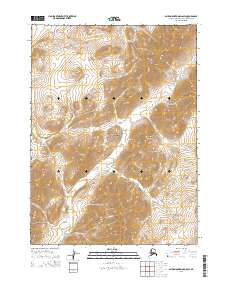
2015 Map of Baird Mountains D-6 SW
USGS Topo · Published 2015About this map
The Maiyumerak Mountains dominate the eastern reaches of this remote Arctic landscape, situated within the vast boundaries of the Noatak National Preserve. This 2015 survey reveals a terrain defined by high elevation and a network of northward-draining watercourses. The drainage patterns are clearly established by several seasonal streams, including Kungiakrok Cr in the north and the centrally located Uvgoon Cr. Further south, the meandering path of Ahaliknak Cr cuts through the high ground, illustrating the complex hydrography of the Baird Mountains region. With no roads or permanent settlements indicated, the map captures a primitive wilderness state, serving as a primary record of the topographic contours and natural drainage systems that characterize this part of the Northwest Arctic Borough.
Find a feature on this map
11 named features on this map. Tap any name to fly to it.
Don’t see what you’re looking for? This feature index may not catch every label — zoom into the map to look around manually.
Map Details
Editions of this 2015 Baird Mountains D-6 SW Map
This is the sole edition of this map. No revisions or reprints were ever made.
Other maps of this area

1951 · Baird Mountains
USGS Topo · 1:250,000

1951 · Noatak
USGS Topo · 1:250,000

1955 · Noatak
USGS Topo · 1:250,000

1955 · Noatak D-1
USGS Topo · 1:63,360

1955 · Baird Mountains D-6
USGS Topo · 1:63,360

1955 · Noatak C-1
USGS Topo · 1:63,360
1955 · Baird Mountains C-6
USGS Topo · 1:63,360

1956 · Baird Mountains
USGS Topo · 1:250,000

1964 · Noatak
USGS Topo · 1:250,000

1965 · Baird Mountains
USGS Topo · 1:250,000