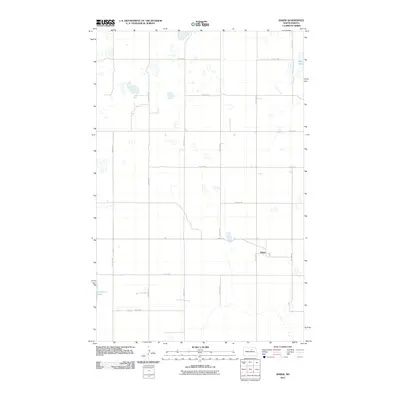
2011 Map of Baker
USGS Topo · Published 2011About this map
Baker sits at the heart of this Benson County landscape, where the prairie is defined by a rigorous grid of section-line roads and numerous small wetlands. This 2011 survey illustrates the rural infrastructure of central North Dakota, anchored by the intersection of 52nd St Ne and 45th Ave Ne. The geography is characterized by its glacial potholes and larger water bodies like Twin Lakes in the northeast and Cranberry Lake in the southwest. The systematic layout of routes such as 57th St Ne and 41st Ave Ne reveals the enduring importance of the Public Land Survey System in organizing this agricultural region, providing a clear view of the farmsteads and transport corridors at the start of the 2010s.
Find a feature on this map
17 named features on this map. Tap any name to fly to it.
Don’t see what you’re looking for? This feature index may not catch every label — zoom into the map to look around manually.
Map Details
Editions of this 2011 Baker Map
This is the sole edition of this map. No revisions or reprints were ever made.
Other maps of this area

1953 · Devils Lake
USGS Topo · 1:250,000

1956 · Devils Lake
USGS Topo · 1:250,000

1958 · Fillmore
USGS Topo · 1:24,000

1958 · Baker
USGS Topo · 1:24,000
1958 · Esmond
USGS Topo · 1:24,000

1958 · Harlow
USGS Topo · 1:24,000
1958 · Harlow SE
USGS Topo · 1:24,000
1958 · Harlow SW
USGS Topo · 1:24,000

1971 · Knox
USGS Topo · 1:24,000

1971 · York
USGS Topo · 1:24,000