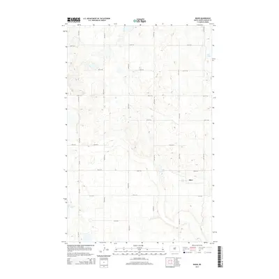
2014 Map of Baker
USGS Topo · Published 2014About this map
Baker occupies the southeastern portion of this Benson County landscape, surrounded by the characteristic prairie pothole topography of the North Dakota plains. The terrain is defined by numerous small depressions and wetland basins, including the larger Twin Lakes in the northeast and Cranberry Lake in the southwest. A rigid section-line road network, featuring routes such as 41st Ave NE and 57th St NE, bisects the area into agricultural blocks, a testament to the systematic land division of the Great Plains. Apart from the small concentration of structures at Baker, the map shows a sparse settlement pattern dominated by open fields and isolated water bodies, reflecting the region's enduring focus on large-scale farming and rural connectivity through county roads like Cr-0314.
Find a feature on this map
18 named features on this map. Tap any name to fly to it.
Don’t see what you’re looking for? This feature index may not catch every label — zoom into the map to look around manually.
Map Details
Editions of this 2014 Baker Map
This is the sole edition of this map. No revisions or reprints were ever made.
Other maps of this area

1953 · Devils Lake
USGS Topo · 1:250,000

1956 · Devils Lake
USGS Topo · 1:250,000

1958 · Fillmore
USGS Topo · 1:24,000

1958 · Baker
USGS Topo · 1:24,000
1958 · Esmond
USGS Topo · 1:24,000

1958 · Harlow
USGS Topo · 1:24,000
1958 · Harlow SE
USGS Topo · 1:24,000
1958 · Harlow SW
USGS Topo · 1:24,000

1971 · Knox
USGS Topo · 1:24,000

1971 · York
USGS Topo · 1:24,000