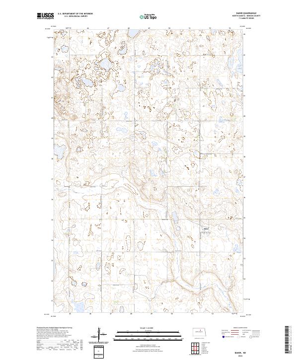
2024 Map of Baker
USGS Topo · Published 2024About this map
Baker sits as a quiet focal point in this portion of Benson County, where the landscape is defined by the extensive wetlands of the Benson County Waterfowl Production Area. This conservation area spans multiple sections, protecting the vital prairie pothole habitat characteristic of the region. The map reveals a grid-like network of rural routes, including 57th St NE and Slotto Rd, which provide access to isolated farmsteads and the scattered water bodies of the plains. To the northeast, the presence of Twin Lakes further illustrates the significance of surface water in this agricultural and conservation-focused environment. This survey captures the structured organization of the Public Land Survey System, with township boundaries like t155n r70w clearly delineating the vast, open spaces of the North Dakota prairie.
Find a feature on this map
16 named features on this map. Tap any name to fly to it.
Don’t see what you’re looking for? This feature index may not catch every label — zoom into the map to look around manually.
Map Details
Editions of this 2024 Baker Map
This is the sole edition of this map. No revisions or reprints were ever made.
Other maps of this area

1953 · Devils Lake
USGS Topo · 1:250,000

1956 · Devils Lake
USGS Topo · 1:250,000

1958 · Fillmore
USGS Topo · 1:24,000

1958 · Baker
USGS Topo · 1:24,000
1958 · Esmond
USGS Topo · 1:24,000

1958 · Harlow
USGS Topo · 1:24,000
1958 · Harlow SE
USGS Topo · 1:24,000
1958 · Harlow SW
USGS Topo · 1:24,000

1971 · Knox
USGS Topo · 1:24,000

1971 · York
USGS Topo · 1:24,000