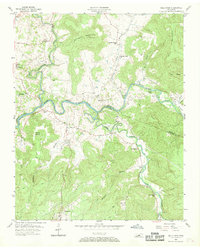
1956 Map of Bald Knob
USGS Topo · Published 1970About this map
Spencer anchors the southern edge of this mid-century landscape where the White Co and Van Buren Co border follows the winding course of the Caney Fork. The terrain is defined by dramatic elevation changes, from the alluvial plains of Dry Bottom to the high ridges of Milksick Mountain and Millstone Mountain. This area illustrates a pattern of small upland settlements and valley communities connected by a network of trails and jeep paths, rather than major highways.
Find a feature on this map
43 named features on this map. Tap any name to fly to it.
Don’t see what you’re looking for? This feature index may not catch every label — zoom into the map to look around manually.
Map Details
Editions of this 1956 Bald Knob Map
3 editions found
Other maps of this area

1892 · Pikeville
USGS Topo · 1:125,000

1893 · Mc Minnville
USGS Topo · 1:125,000

1895 · Mc Minnville
USGS Topo · 1:125,000

1895 · Pikeville
USGS Topo · 1:125,000

1943 · Cookeville
USGS Topo · 1:100,000

1944 · Cookeville
USGS Topo · 1:100,000

1953 · Chattanooga
USGS Topo · 1:250,000

1954 · De Rossett
USGS Topo · 1:24,000

1954 · Sparta
USGS Topo · 1:24,000
1954 · Lonewood
USGS Topo · 1:24,000