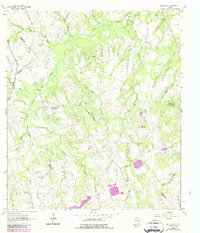
1963 Map of Bald Mound
USGS Topo · Published 1987About this map
The convergence of Gonzales, Wilson, and Karnes counties defines this rural South Texas landscape, marked by a dense network of watercourses and topographical rises. A series of drainages, including Elm Creek, Brushy Creek, and Mustang Creek, wind through the terrain, punctuated by the distinctive elevations of Bald Mound and Rocky Mound. The map reveals a pastoral economy supported by specialized landmarks like an Oil Well and a Flowing Well, while industrial activity is noted at a southern Quarry and scattered Gravel Pits. Local history is anchored by a rural Cem, providing a focal point for genealogists researching the families who settled this tri-county intersection. The presence of numerous named branches, such as Rusten Branch and Panther Branch, suggests a finely-divided land usage pattern where seasonal water access was critical for livestock and agriculture.
Find a feature on this map
30 named features on this map. Tap any name to fly to it.
Don’t see what you’re looking for? This feature index may not catch every label — zoom into the map to look around manually.
Map Details
Editions of this 1963 Bald Mound Map
3 editions found
Other maps of this area

1920 · Smiley
USGS Topo · 1:125,000

1942 · Dewville
USGS Topo · 1:62,500

1953 · Seguin
USGS Topo · 1:250,000

1956 · Dewville
USGS Topo · 1:62,500

1958 · Seguin
USGS Topo · 1:250,000

1961 · Sample
USGS Topo · 1:24,000

1961 · Nixon
USGS Topo · 1:24,000
1961 · Pilgrim
USGS Topo · 1:24,000

1961 · New Davy
USGS Topo · 1:24,000

1961 · Gillett
USGS Topo · 1:24,000