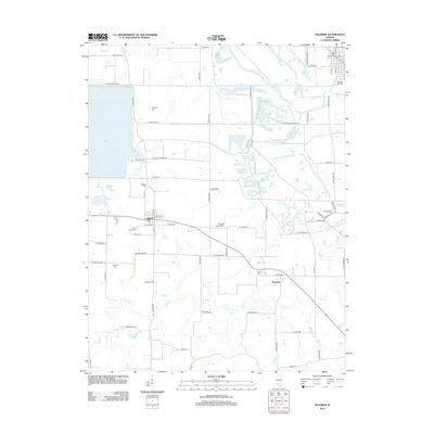
2012 Map of Baldwin
USGS Topo · Published 2012About this map
Baldwin and Houston anchor this section of the Illinois interior, where a network of rural roads such as Sackwitz Rd and Houston Rd defines the landscape. The most prominent man-made feature is the large Baldwin Power Plant Cooling Lake on the western edge, a significant alteration of the local topography that contrasts with the natural winding paths of Plum Cr and Doza Cr. For those tracing family histories in the area, the map preserves the locations of several burial grounds, including Leinecke Cem, Marissa City Cem, Baldwin Cem, and Schmoll Cem. The presence of the Redpath RLA Airport and various family-named routes like W Doza School Rd suggests a community where modern industry and deep-rooted agricultural patterns coexist.
Find a feature on this map
70 named features on this map. Tap any name to fly to it.
Don’t see what you’re looking for? This feature index may not catch every label — zoom into the map to look around manually.
Map Details
Editions of this 2012 Baldwin Map
This is the sole edition of this map. No revisions or reprints were ever made.
Other maps of this area

1910 · Okawville
USGS Topo · 1:62,500

1912 · New Athens
USGS Topo · 1:62,500

1912 · Baldwin
USGS Topo · 1:62,500

1914 · Baldwin
USGS Topo · 1:62,500

1914 · Coulterville
USGS Topo · 1:62,500

1917 · Coulterville
USGS Topo · 1:62,500

1940 · Okawville
USGS Topo · 1:62,500

1942 · Baldwin
USGS Topo · 1:62,500

1954 · New Athens West
USGS Topo · 1:24,000
1954 · New Athens East
USGS Topo · 1:24,000