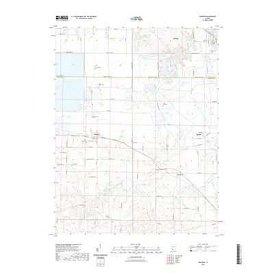
2021 Map of Baldwin
USGS Topo · Published 2021About this map
The boundary between St Clair Co and Randolph Co bisects this landscape, which is defined by a dense network of family-named cemeteries and rural settlements. Baldwin Lake dominates the northwest corner, providing a contrast to the agricultural patterns and creek drainages that shape the rest of the quadrangle. For genealogists, the map is remarkably information-rich, preserving the locations of numerous burial grounds such as Saint Johns Cem, Spitz Bilgere Cem, and Jordan Grove Cem. The small communities of Baldwin, Houston, and Sparta are linked by a grid of rural roads like Risdon School Rd and Randolph Co Line Rd, illustrating the persistence of early township divisions. These labels and coordinates offer a clear look at the spatial relationship between historic church sites and the surrounding farmsteads along Doza Cr and Plum Cr.
Find a feature on this map
69 named features on this map. Tap any name to fly to it.
Don’t see what you’re looking for? This feature index may not catch every label — zoom into the map to look around manually.
Map Details
Editions of this 2021 Baldwin Map
This is the sole edition of this map. No revisions or reprints were ever made.
Other maps of this area

1910 · Okawville
USGS Topo · 1:62,500

1912 · New Athens
USGS Topo · 1:62,500

1912 · Baldwin
USGS Topo · 1:62,500

1914 · Baldwin
USGS Topo · 1:62,500

1914 · Coulterville
USGS Topo · 1:62,500

1917 · Coulterville
USGS Topo · 1:62,500

1940 · Okawville
USGS Topo · 1:62,500

1942 · Baldwin
USGS Topo · 1:62,500

1954 · New Athens West
USGS Topo · 1:24,000
1954 · New Athens East
USGS Topo · 1:24,000