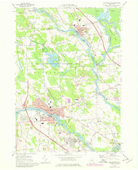
1973 Map of Baldwinsville
USGS Topo · Published 1978About this map
The Seneca River, Oneida River, and Oswego River converge in a complex waterway system that defines the central geography of this central New York region. This confluence, known simply as Three Rivers, sits adjacent to the sprawling Three Rivers State Game Management Area, which dominates the landscape between Phoenix and Baldwinsville. The map illustrates a transitional period of development, notably featuring the Lysander New Community and several new residential subdivisions shown in purple revision, indicating growth in the late 1970s. Industrial and transport history is represented by the Erie Canal segments and the extensive Conrail lines that serve the river towns. Local community life is detailed through numerous schools like the Elizabeth St Sch and Dillon Sch, along with several historic cemeteries including Riverside Cemetery and St Marys Cem near the riverbanks.
Find a feature on this map
56 named features on this map. Tap any name to fly to it.
Don’t see what you’re looking for? This feature index may not catch every label — zoom into the map to look around manually.
Map Details
Editions of this 1973 Baldwinsville Map
Other maps of this area

1895 · Syracuse
USGS Topo · 1:62,500

1898 · Syracuse
USGS Topo · 1:62,500

1900 · Baldwinsville
USGS Topo · 1:62,500

1900 · Fulton
USGS Topo · 1:62,500

1905 · Mexico
USGS Topo · 1:62,500

1939 · Syracuse West
USGS Topo · 1:24,000

1940 · Brewerton
USGS Topo · 1:24,000

1943 · Jordan
USGS Topo · 1:31,680

1943 · Lysander
USGS Topo · 1:31,680

1943 · Brewerton
USGS Topo · 1:31,680