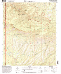
1997 Map of Baldy Bill Point
USGS Topo · Published 2000About this map
The high canyons and springs of the Apache National Forest dominate this landscape on the border of Greenlee and Graham counties. The northern portion is defined by the Bear Wallow Wilderness, where steep drainage networks like Bear Creek and Wallow Creek converge. This area reflects a wilderness management era focused on preserving the primitive character of the high country, while the southern reaches show the infrastructure of ranching and forestry. Scattered throughout are essential water sources such as Horse Pasture Spring, Turkey Spring, and Miller Spring, alongside stock management features like McBride Corral and Warren Tank. The western edge of the sheet is marked by the San Carlos Indian Reservation Boundary, cutting through the deep topography of Ariz Canyon and Helen Canyon. Landmarks like the Lookout Tower and Saulsbers Cabin provide evidence of human activity in this otherwise high-altitude backcountry.
Find a feature on this map
57 named features on this map. Tap any name to fly to it.
Don’t see what you’re looking for? This feature index may not catch every label — zoom into the map to look around manually.
Map Details
Editions of this 1997 Baldy Bill Point Map
This is the sole edition of this map. No revisions or reprints were ever made.
Other maps of this area

1913 · Morenci
USGS Topo · 1:125,000

1915 · Morenci
USGS Topo · 1:125,000

1922 · Nutrioso
USGS Topo · 1:125,000

1954 · Clifton
USGS Topo · 1:250,000

1957 · Clifton
USGS Topo · 1:250,000

1958 · Clifton
USGS Topo · 1:250,000

1958 · Hannagan Meadow
USGS Topo · 1:62,500

1962 · Clifton
USGS Topo · 1:250,000

1967 · Freezeout Mountain
USGS Topo · 1:24,000

1967 · Robinson Mesa
USGS Topo · 1:24,000