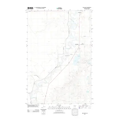
2013 Map of Ball Bluff
USGS Topo · Published 2013About this map
The Mississippi River defines the northern reaches of this Aitkin County landscape, winding past the small settlement of Jacobson at the junction of MN-65 and MN-200. The river's serpentine path is flanked by a complex system of backwaters and wetlands that characterize this part of northern Minnesota. To the south, the namesake community of Ball Bluff sits near the eastern bank, serving as a local hub between the river and a cluster of inland waters including Ball Bluff Lake and Little Ball Bluff Lake.
Find a feature on this map
25 named features on this map. Tap any name to fly to it.
Don’t see what you’re looking for? This feature index may not catch every label — zoom into the map to look around manually.
Map Details
Editions of this 2013 Ball Bluff Map
This is the sole edition of this map. No revisions or reprints were ever made.
Other maps of this area

1953 · Duluth
USGS Topo · 1:250,000

1954 · Hibbing
USGS Topo · 1:250,000

1957 · Hibbing
USGS Topo · 1:250,000

1958 · Hibbing
USGS Topo · 1:250,000

1958 · Duluth
USGS Topo · 1:250,000

1964 · Hibbing
USGS Topo · 1:250,000

1970 · Split Hand Lake
USGS Topo · 1:24,000

1970 · Rabey
USGS Topo · 1:24,000
1970 · Swan River
USGS Topo · 1:24,000

1970 · Sanders Lake
USGS Topo · 1:24,000