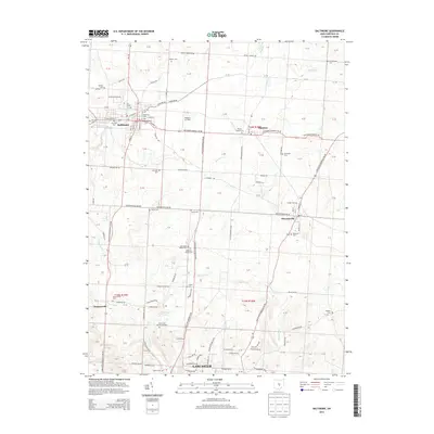
2013 Map of Baltimore
USGS Topo · Published 2013About this map
The villages of Baltimore and Thurston anchor the northern landscape of this Fairfield County region, where the historical footprint of early settlement is clearly visible through a dense network of family and community burial grounds. From the Warner Cem in the north to the Zeigler Cem and Dumontsville Cem further south, these sites provide critical touchpoints for genealogical research. The terrain is defined by a series of waterways, including Walnut Creek and Paw Paw Cr, which cut through the agricultural surroundings.
Find a feature on this map
79 named features on this map. Tap any name to fly to it.
Don’t see what you’re looking for? This feature index may not catch every label — zoom into the map to look around manually.
Map Details
Editions of this 2013 Baltimore Map
This is the sole edition of this map. No revisions or reprints were ever made.
Other maps of this area

1907 · Logan
USGS Topo · 1:62,500

1907 · Lancaster
USGS Topo · 1:62,500

1907 · Thurston
USGS Topo · 1:62,500

1909 · Thornville
USGS Topo · 1:62,500

1909 · Lancaster
USGS Topo · 1:62,500

1909 · Logan
USGS Topo · 1:62,500

1909 · Thurston
USGS Topo · 1:62,500

1947 · Columbus
USGS Topo · 1:250,000

1958 · Carroll
USGS Topo · 1:24,000
1958 · Amanda
USGS Topo · 1:24,000