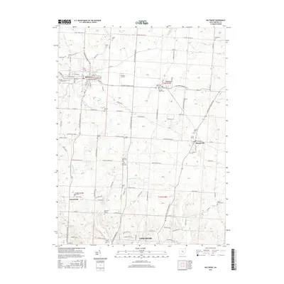
2016 Map of Baltimore
USGS Topo · Published 2016About this map
Baltimore and its surrounding Fairfield County townships are centered in a landscape defined by agricultural tradition and small-town growth. This 2016 survey highlights a dense collection of genealogical sites, from the Basil Memorial Cem and Gehegan-Old Baltimore Cem in the north to the Old Saint Peters Cem and Dumontsville Cem further south. The map illustrates the convergence of several drainages, including Walnut Creek, Claypools Run, and Pleasant Run, which flow through the rolling terrain between Pleasantville and the northern reaches of Lancaster.
Find a feature on this map
115 named features on this map. Tap any name to fly to it.
Don’t see what you’re looking for? This feature index may not catch every label — zoom into the map to look around manually.
Map Details
Editions of this 2016 Baltimore Map
This is the sole edition of this map. No revisions or reprints were ever made.
Other maps of this area

1907 · Logan
USGS Topo · 1:62,500

1907 · Lancaster
USGS Topo · 1:62,500

1907 · Thurston
USGS Topo · 1:62,500

1909 · Thornville
USGS Topo · 1:62,500

1909 · Lancaster
USGS Topo · 1:62,500

1909 · Logan
USGS Topo · 1:62,500

1909 · Thurston
USGS Topo · 1:62,500

1947 · Columbus
USGS Topo · 1:250,000

1958 · Carroll
USGS Topo · 1:24,000
1958 · Amanda
USGS Topo · 1:24,000