
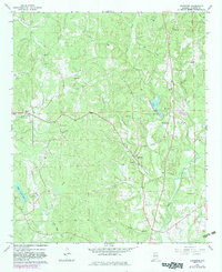
1967 Map of Bankston
USGS Topo · Published 1968About this map
Bankston and its central substation anchor this late 1960s rural landscape in Fayette County, where the Southern railroad corridor dictates the movement of people and resources between Stough and Cleveland. The terrain is defined by a dense network of small waterways, including Clear Creek and Deadwater Creek, which support localized agriculture and community hubs. Community life is evident in the numerous country churches and burial grounds scattered across the hills, such as Piney Grove Ch, Oak Grove Ch, and Philadelphia Cem.
Find a feature on this map
29 named features on this map. Tap any name to fly to it.
Don’t see what you’re looking for? This feature index may not catch every label — zoom into the map to look around manually.
Map Details
Editions of this 1967 Bankston Map
2 editions found
Other maps of this area

1953 · Birmingham
USGS Topo · 1:250,000

1956 · Birmingham
USGS Topo · 1:250,000

1957 · Birmingham
USGS Topo · 1:250,000

1967 · Winfield SE
USGS Topo · 1:24,000

1967 · Newtonville
USGS Topo · 1:24,000

1967 · Hubbertville
USGS Topo · 1:24,000
1967 · Berry
USGS Topo · 1:24,000

1967 · Fayette
USGS Topo · 1:24,000
1967 · New Lexington
USGS Topo · 1:24,000
1967 · Howard
USGS Topo · 1:24,000