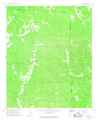
1967 Map of Howard
USGS Topo · Published 1968About this map
Studdards Crossroads and the nearby community of Howard anchor this late 1960s survey of the wooded boundary between Fayette and Walker Counties. The landscape is defined by the winding course of the North River, which receives numerous tributaries like Boxer Creek and Hendon Creek. The area’s rural character is reflected in the high density of small family cemeteries and country churches, including Elm Grove Ch and Pleasant Grove Ch. Physical geography is marked by significant elevations such as Coonero Mountain and Tittle Mountain in the eastern portion of the quadrangle. While largely agricultural and timber-oriented, the presence of a Strip Mine and Gravel Pit indicates the localized extraction industries that supplemented the rural economy. Cultural landmarks like the Campground and Willis Chapel suggest the social centers for these dispersed hillside settlements.
Find a feature on this map
40 named features on this map. Tap any name to fly to it.
Don’t see what you’re looking for? This feature index may not catch every label — zoom into the map to look around manually.
Map Details
Editions of this 1967 Howard Map
3 editions found
Other maps of this area

1893 · Jasper
USGS Topo · 1:125,000

1949 · Townley
USGS Topo · 1:24,000

1949 · Oakman
USGS Topo · 1:24,000

1949 · Nauvoo
USGS Topo · 1:24,000

1950 · Nauvoo
USGS Topo · 1:24,000

1951 · Oakman
USGS Topo · 1:24,000

1951 · Townley
USGS Topo · 1:24,000

1953 · Birmingham
USGS Topo · 1:250,000

1956 · Birmingham
USGS Topo · 1:250,000

1957 · Birmingham
USGS Topo · 1:250,000