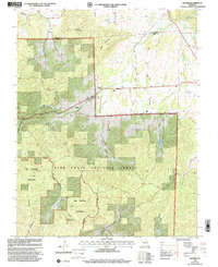
1999 Map of Banner
USGS Topo · Published 2002About this map
Bell Mountain Wilderness dominates the southern portion of this landscape within the Mark Twain National Forest. The rugged topography is defined by significant elevations such as Pruitt Mountain and Logan Mountain, which overlook a network of drainage systems including Cedar Creek and Reid Creek. Human settlement is concentrated in the northern sections, particularly around the community of Banner and the Belleview Valley Nursing Home.
Find a feature on this map
29 named features on this map. Tap any name to fly to it.
Don’t see what you’re looking for? This feature index may not catch every label — zoom into the map to look around manually.
Map Details
Editions of this 1999 Banner Map
This is the sole edition of this map. No revisions or reprints were ever made.
Other maps of this area

1905 · Bonneterre
USGS Topo · 1:62,500

1906 · Potosi
USGS Topo · 1:62,500

1924 · Edgehill
USGS Topo · 1:62,500

1926 · Edgehill
USGS Topo · 1:62,500

1937 · Ironton
USGS Topo · 1:48,000

1945 · Ironton
USGS Topo · 1:62,500

1946 · Ironton
USGS Topo · 1:62,500

1949 · Rolla
USGS Topo · 1:250,000

1953 · Ironton
USGS Topo · 1:62,500

1953 · Rolla
USGS Topo · 1:250,000