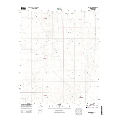
2013 Map of Bar C Bar Ranch
USGS Topo · Published 2013About this map
Bar C Bar Ranch anchors this high-desert landscape in Chaves County, where water management is the primary indicator of human activity. The map reveals a network of infrastructure designed for ranching in an arid environment, including the Redtower Windmill, South Tank, and N Morris Tank. These features, along with the South Mill, show how the land was adapted for livestock grazing in the early 21st century. Natural drainage is defined by the winding course of the Long Arroyo, which traverses the eastern sections of the quadrangle. A long Pipeline cuts diagonally across the terrain, illustrating the modern industrial layer superimposed on the traditional grazing lands. Access to this corner of New Mexico is provided by local routes like Merlinda Rd and Langenegger, which connect the scattered ranching operations across the township boundaries.
Find a feature on this map
15 named features on this map. Tap any name to fly to it.
Don’t see what you’re looking for? This feature index may not catch every label — zoom into the map to look around manually.
Map Details
Editions of this 2013 Bar C Bar Ranch Map
This is the sole edition of this map. No revisions or reprints were ever made.
Other maps of this area

1949 · Wade Ranch
USGS Topo · 1:24,000

1949 · Malstrom Ranch
USGS Topo · 1:24,000

1950 · Bottomless Lakes
USGS Topo · 1:24,000

1950 · Dexter East
USGS Topo · 1:24,000

1951 · Ninemile Well
USGS Topo · 1:24,000

1951 · King Camp
USGS Topo · 1:24,000

1951 · Hagerman
USGS Topo · 1:24,000

1952 · Connor Well
USGS Topo · 1:24,000

1952 · Bar C Bar Ranch
USGS Topo · 1:24,000

1955 · Roswell
USGS Topo · 1:250,000