
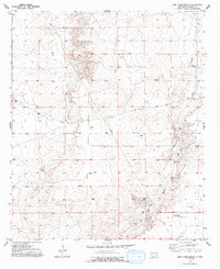
1952 Map of Bar C Bar Ranch
USGS Topo · Published 1953About this map
Bar C Bar Ranch anchors this high-plains landscape in Chaves County, where water management defines the human footprint on the arid terrain. Surveyed in the early 1950s, the map reveals a sophisticated network of ranching infrastructure, including North Morris Tank, South Tank, and numerous unnamed cisterns and tanks. These features, along with specialized landmarks like the Redtower Windmill, highlight the critical importance of groundwater for cattle operations in a region where the Long Arroyo provides the primary natural drainage. Industrial development is present but limited, marked by a subterranean Pipe Line and a single Oil Well (Aband). Geodetic markers like White and Sandy rise above the basin, serving as essential reference points for both the original surveyors and modern researchers tracing the evolution of southeastern New Mexico land use.
Find a feature on this map
13 named features on this map. Tap any name to fly to it.
Don’t see what you’re looking for? This feature index may not catch every label — zoom into the map to look around manually.
Map Details
Editions of this 1952 Bar C Bar Ranch Map
2 editions found
Other maps of this area

1949 · Wade Ranch
USGS Topo · 1:24,000

1949 · Malstrom Ranch
USGS Topo · 1:24,000

1950 · Bottomless Lakes
USGS Topo · 1:24,000

1950 · Dexter East
USGS Topo · 1:24,000

1951 · Ninemile Well
USGS Topo · 1:24,000

1951 · King Camp
USGS Topo · 1:24,000

1951 · Hagerman
USGS Topo · 1:24,000

1952 · Connor Well
USGS Topo · 1:24,000

1955 · Roswell
USGS Topo · 1:250,000

1958 · Roswell
USGS Topo · 1:250,000