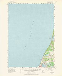
1956 Map of Bar Lake
USGS Topo · Published 1968About this map
Lake Michigan dominates the western half of this mid-century survey, defining a coastline shaped by complex inland waterways. The settlement of Manistee serves as a hub where the industrial and natural landscapes converge, featuring a network of bayous including Peters Bayou and Tatches Bayou that lead into Manistee Lake. Transportation infrastructure is well-established, with the Chesapeake and Ohio railroad corridor running parallel to the shore and the Manistee-Blacker Airport situated to the east. For the local historian, the map preserves the locations of rural landmarks like the Newland Sch and Oak Grove Cem. The northern shoreline is marked by Portage Point at the mouth of Portage Lake, while the protected acreage of the Manistee National Forest and Orchard Beach State Park illustrates the region's balance of development and conservation during the 1950s.
Find a feature on this map
31 named features on this map. Tap any name to fly to it.
Don’t see what you’re looking for? This feature index may not catch every label — zoom into the map to look around manually.
Map Details
Editions of this 1956 Bar Lake Map
Other maps of this area

1954 · Manitowoc
USGS Topo · 1:250,000

1956 · Onekama
USGS Topo · 1:62,500

1956 · Bar Lake
USGS Topo · 1:62,500

1956 · Frankfort
USGS Topo · 1:62,500

1957 · Freesoil
USGS Topo · 1:62,500

1958 · Manitowoc
USGS Topo · 1:250,000

1958 · Manistee
USGS Topo · 1:62,500

1976 · Frankfort SW
USGS Topo · 1:24,000

1976 · Onekama NW
USGS Topo · 1:24,000

1976 · Onekama SW
USGS Topo · 1:24,000