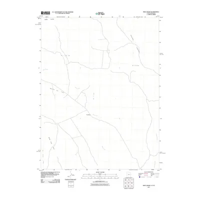
2011 Map of Bar X Wash
USGS Topo · Published 2011About this map
Bar X Gas Field and the Stateline Gas Field anchor this 2011 survey of the high desert landscape along the Colorado-Utah border. The terrain is defined by the massive southern face of the Book Cliffs, which overlook a network of seasonal watercourses and mesas. Natural drainage patterns are clearly visible, following the paths of Bar X Wash, Bitter Creek, and McDonald Creek as they cut through the arid floor. The map highlights the intersection of industrial energy extraction and the natural topography of Ray Mesa and Prairie Canyon. This document provides a clear view of the modern infrastructure required for gas production in a remote western environment, showing the access roads that weave between deep drainages like Winter Camp Draw and San Arroyo Wash.
Find a feature on this map
10 named features on this map. Tap any name to fly to it.
Don’t see what you’re looking for? This feature index may not catch every label — zoom into the map to look around manually.
Map Details
Editions of this 2011 Bar X Wash Map
This is the sole edition of this map. No revisions or reprints were ever made.
Other maps of this area

1885 · East Tavaputs
USGS Topo · 1:250,000

1956 · Grand Junction
USGS Topo · 1:250,000

1959 · Grand Junction
USGS Topo · 1:250,000

1960 · Grand Junction
USGS Topo · 1:250,000

1962 · Grand Junction
USGS Topo · 1:250,000

1964 · Grand Junction
USGS Topo · 1:250,000

1965 · Grand Junction
USGS Topo · 1:250,000

1968 · Badger Wash
USGS Topo · 1:24,000
1968 · Carbonera
USGS Topo · 1:24,000
1968 · Ruby Canyon
USGS Topo · 1:24,000