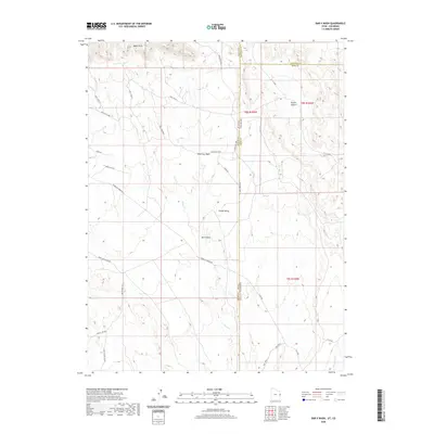
2020 Map of Bar X Wash
USGS Topo · Published 2020About this map
Book Cliffs dominate the northern landscape of this high-desert region where the borders of Utah and Colorado meet. This 2020 survey illustrates a remote territory defined by industrial energy infrastructure and expansive drainage systems like Wild Cow Wash and the namesake Bar X Wash. The presence of the Bar X Gas Field and Mountain Fuel infrastructure indicates the area's continued importance for resource extraction. Below the prominent escarpment labeled Below The Rim, a network of utility and access roads such as Bookcliff Ridge Rd and the Mac Intyre Cutoff navigate the complex terrain of Grand Valley. Water is scarce, traced only by the winding paths of Bitter Cr and McDonald Cr, which cut through the arid canyons and basins.
Find a feature on this map
31 named features on this map. Tap any name to fly to it.
Don’t see what you’re looking for? This feature index may not catch every label — zoom into the map to look around manually.
Map Details
Editions of this 2020 Bar X Wash Map
This is the sole edition of this map. No revisions or reprints were ever made.
Other maps of this area

1885 · East Tavaputs
USGS Topo · 1:250,000

1956 · Grand Junction
USGS Topo · 1:250,000

1959 · Grand Junction
USGS Topo · 1:250,000

1960 · Grand Junction
USGS Topo · 1:250,000

1962 · Grand Junction
USGS Topo · 1:250,000

1964 · Grand Junction
USGS Topo · 1:250,000

1965 · Grand Junction
USGS Topo · 1:250,000

1968 · Badger Wash
USGS Topo · 1:24,000
1968 · Carbonera
USGS Topo · 1:24,000
1968 · Ruby Canyon
USGS Topo · 1:24,000