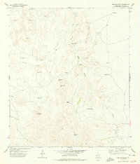
1978 Map of Bare Mountain
USGS Topo · Published 1978About this map
Bare Mountain serves as the focal point for this 1970s survey of west Texas, revealing a landscape defined by an intricate network of water management infrastructure. In this arid region of Jeff Davis County, the distribution of ranching resources is meticulously documented through numerous sites like Walnut Well, Twiford Spring, and the Mescalero Windmills. The map illustrates how human activity follows the natural drainage patterns of Bunton Draw and Rincon Canyon, where a high density of water tanks, including Pinto Bean Tank and Landrein Tank, support local livestock operations. Distinctive topographic features such as the Buzzard Roost Hills and Sams Butte provide significant landmarks for navigating the high-desert terrain. For those researching land use or local genealogy, the names associated with these water sources, such as Sheep Camp Windmill and Screwbean Windmill, offer a clear picture of the rangeland development in the late twentieth century.
Find a feature on this map
27 named features on this map. Tap any name to fly to it.
Don’t see what you’re looking for? This feature index may not catch every label — zoom into the map to look around manually.
Map Details
Editions of this 1978 Bare Mountain Map
This is the sole edition of this map. No revisions or reprints were ever made.
Other maps of this area

1894 · Valentine
USGS Topo · 1:125,000

1897 · Valentine
USGS Topo · 1:125,000

1943 · Valentine
USGS Topo · 1:125,000

1959 · Marfa
USGS Topo · 1:250,000

1965 · Marfa
USGS Topo · 1:250,000
1978 · Herds Pass
USGS Topo · 1:24,000
1978 · Boggy Draw
USGS Topo · 1:24,000
1978 · Echo Canyon
USGS Topo · 1:24,000
1978 · El Muerto Peak
USGS Topo · 1:24,000
1978 · Robbers Roost Canyon
USGS Topo · 1:24,000