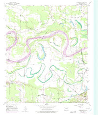
1950 Map of Barkman
USGS Topo · Published 1975About this map
The Red River defines the shifting boundary between Texas and Arkansas in this mid-century survey, creating a complex landscape of oxbow lakes and meandering bayous. The river's historical path has left behind numerous water bodies such as Roseborough Lake, Smith Lake, and Rush Lake, alongside the curiously named The Old Sag. This fluvial environment dictated the layout of local infrastructure, where rural communities like Barkman and Wamba developed alongside essential institutions such as the Rosenwald Sch and several country churches.
Find a feature on this map
31 named features on this map. Tap any name to fly to it.
Don’t see what you’re looking for? This feature index may not catch every label — zoom into the map to look around manually.
Map Details
Editions of this 1950 Barkman Map
5 editions found
Other maps of this area

1909 · New Boston
USGS Topo · 1:62,500

1909 · Texarkana
USGS Topo · 1:62,500

1950 · Redbank
USGS Topo · 1:24,000

1950 · Ashdown East
USGS Topo · 1:24,000

1950 · Ashdown West
USGS Topo · 1:24,000

1950 · Ogden
USGS Topo · 1:24,000

1950 · Barkman
USGS Topo · 1:24,000

1951 · Redbank
USGS Topo · 1:24,000

1951 · Ashdown West
USGS Topo · 1:24,000

1951 · Ogden
USGS Topo · 1:24,000