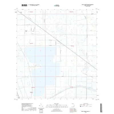
2018 Map of Barley Barber Swamp
USGS Topo · Published 2018About this map
Barley Barber Swamp dominates the central portion of this Martin County landscape, a preserved remnant of the ancient Florida wetlands that once stretched toward the coast. By 2018, the area displays a complex water management and transportation network, defined by the Saint Lucie Canal and the Okeechobee Waterway traversing the southern sections. The industrial and agricultural heritage of the region is evident in the straight lines of the L-65 Canal and a grid of rural roads like Farm Dairy Rd. Local settlement patterns are anchored by Zana in the northwest and Bessemer in the southwest, while the Florida East Coast railway runs parallel to the waterway, marking a critical corridor for regional commerce. The presence of Horseshoe Acres Airpark underscores the transition toward more modern, specialized land use in this traditionally wild and agricultural terrain.
Find a feature on this map
33 named features on this map. Tap any name to fly to it.
Don’t see what you’re looking for? This feature index may not catch every label — zoom into the map to look around manually.
Map Details
Editions of this 2018 Barley Barber Swamp Map
This is the sole edition of this map. No revisions or reprints were ever made.
Other maps of this area

1953 · Okeechobee 4 SW
USGS Topo · 1:24,000

1953 · Okeechobee 4 SE
USGS Topo · 1:24,000

1953 · Okeechobee 4 NE
USGS Topo · 1:24,000

1953 · Okeechobee 4 NW
USGS Topo · 1:24,000

1953 · Indian Town NW
USGS Topo · 1:24,000

1953 · Indian Town
USGS Topo · 1:24,000

1956 · West Palm Beach
USGS Topo · 1:250,000

1956 · Fort Pierce
USGS Topo · 1:250,000

1957 · West Palm Beach
USGS Topo · 1:250,000

1958 · Fort Pierce
USGS Topo · 1:250,000