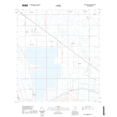
2021 Map of Barley Barber Swamp
USGS Topo · Published 2021About this map
Indiantown sits at the heart of this Martin County landscape, where the agricultural grid of south Florida meets the preserved wetlands of the Barley Barber Swamp. The map reflects a region defined by water management and transit, anchored by the Saint Lucie Canal and the Okeechobee Waterway to the south. These engineered channels, alongside the Florida East Coast rail line, illustrate the historical infrastructure required to develop the Everglades’ northern fringes. To the north, the terrain transitions into the Allapattah Flats, a low-lying area crisscrossed by trails like the Allapattah Flats Trl. Smaller settlements such as Bessemer and Zana are connected by a network of local roads including SW Fox Brown Rd and SW Tommy Clements St, while the Horseshoe Acres Airpark highlights the area's modern utility. This survey captures a moment in the 21st century where vast conservation areas and rural homesteads coexist with the state's vital inland water arteries.
Find a feature on this map
33 named features on this map. Tap any name to fly to it.
Don’t see what you’re looking for? This feature index may not catch every label — zoom into the map to look around manually.
Map Details
Editions of this 2021 Barley Barber Swamp Map
This is the sole edition of this map. No revisions or reprints were ever made.
Other maps of this area

1953 · Okeechobee 4 SW
USGS Topo · 1:24,000

1953 · Okeechobee 4 SE
USGS Topo · 1:24,000

1953 · Okeechobee 4 NE
USGS Topo · 1:24,000

1953 · Okeechobee 4 NW
USGS Topo · 1:24,000

1953 · Indian Town NW
USGS Topo · 1:24,000

1953 · Indian Town
USGS Topo · 1:24,000

1956 · West Palm Beach
USGS Topo · 1:250,000

1956 · Fort Pierce
USGS Topo · 1:250,000

1957 · West Palm Beach
USGS Topo · 1:250,000

1958 · Fort Pierce
USGS Topo · 1:250,000