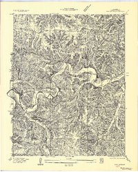
1957 Map of Barnumton
USGS Topo · Published 1957About this map
The Niangua River and its southern fork, the Little Niangua River, define this mid-1930s landscape in central Missouri. Following the completion of the Bagnell Dam, the Lake of the Ozarks backfills these deep river valleys, creating the characteristic branching shoreline of the region. The map captures the transition of the valley floor, where former river crossings like the Nonsuch Ferry are noted in the newly flooded terrain.
Find a feature on this map
16 named features on this map. Tap any name to fly to it.
Don’t see what you’re looking for? This feature index may not catch every label — zoom into the map to look around manually.
Map Details
Editions of this 1957 Barnumton Map
This is the sole edition of this map. No revisions or reprints were ever made.
Other maps of this area

1884 · Bolivar
USGS Topo · 1:125,000

1887 · Warsaw
USGS Topo · 1:125,000

1888 · Versailles
USGS Topo · 1:125,000

1892 · Bolivar
USGS Topo · 1:125,000

1893 · Versailles
USGS Topo · 1:125,000

1894 · Warsaw
USGS Topo · 1:125,000

1934 · Macks Creek
USGS Topo · 1:48,000

1934 · Purvis
USGS Topo · 1:24,000

1934 · Irontown Ferry
USGS Topo · 1:24,000

1934 · Green Bay Terrace
USGS Topo · 1:24,000