
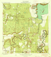
1930 Map of Barreda
USGS Topo · Published 1930About this map
Resaca de los Cuates winds through the alluvial landscape of the lower Rio Grande valley, defining the drainage patterns and early settlement hubs of southern Cameron County. This 1930 survey, which utilizes early aerial photography by the U.S. Geological Survey, details a region transitioning into intensive irrigation and rail-based agriculture. The St Louis Brownsville and Mexico Railway cuts a straight diagonal across the oxbows, anchoring the community of Barreda and the nearby Barreda Park. Local infrastructure is prominent, from the District No 6 Second Lift Pumping Sta to the historic Old Military Road. The map also captures several family-named ranching sites such as Soldado Ranch and Naranjo Ranch, alongside Naranjo Vista, illustrating the localized land divisions and community centers established before mid-century modernization changed the rural character of the borderlands.
Find a feature on this map
18 named features on this map. Tap any name to fly to it.
Don’t see what you’re looking for? This feature index may not catch every label — zoom into the map to look around manually.
Map Details
Editions of this 1930 Barreda Map
This is the sole edition of this map. No revisions or reprints were ever made.
Other maps of this area

1929 · Rio Hondo
USGS Topo · 1:24,000

1929 · Harlingen
USGS Topo · 1:24,000

1929 · La Paloma
USGS Topo · 1:24,000

1930 · Los Fresnos
USGS Topo · 1:24,000

1930 · West Brownsville
USGS Topo · 1:24,000

1930 · Laguna Atascosa
USGS Topo · 1:24,000

1930 · East Brownsville
USGS Topo · 1:24,000

1932 · Rio Hondo
USGS Topo · 1:31,680

1932 · Harlingen
USGS Topo · 1:31,680
1936 · Laguna Atascosa
USGS Topo · 1:31,680