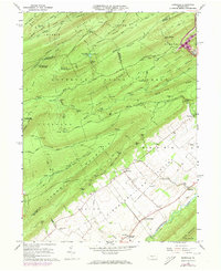
1966 Map of Barrville
USGS Topo · Published 1973About this map
Kishacoquillas Valley anchors the southeastern landscape of this 1966 survey, where the rolling agricultural floor meets the steep ascent of Standing Stone Mountain. The small settlement of Barrville serves as a focal point near the mountain's base, supported by local institutions like the Barrville Sch and nearby Mountain View Sch. To the northwest, the terrain shifts dramatically into a series of ridges and gaps, including Stone Gap and Bailey Gap, which define the rugged boundary between Mifflin Co, Huntingdon Co, and Centre Co.
Find a feature on this map
89 named features on this map. Tap any name to fly to it.
Don’t see what you’re looking for? This feature index may not catch every label — zoom into the map to look around manually.
Map Details
Editions of this 1966 Barrville Map
3 editions found
Other maps of this area

1908 · Bellefonte
USGS Topo · 1:62,500

1909 · Bellefonte
USGS Topo · 1:62,500

1919 · Menno
USGS Topo · 1:62,500

1924 · Centre Hall
USGS Topo · 1:62,500

1924 · Lewistown
USGS Topo · 1:62,500

1927 · Lewisburg
USGS Topo · 1:62,500

1929 · Centre Hall
USGS Topo · 1:62,500

1935 · Allensville
USGS Topo · 1:62,500

1938 · Allensville
USGS Topo · 1:62,500

1943 · Lewistown
USGS Topo · 1:125,000
Featured Places
- Granville Township, PA
- Jackson Township, PA
- Brown Township, PA
- Reedsville, Brown Township
- Kishacoquillas, Brown Township