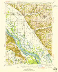
1936 Map of Barry
USGS Topo · Published 1955About this map
The Mississippi River forms a sprawling network of chutes, sloughs, and islands along the border of Illinois and Missouri in the 1930s. The landscape is defined by the massive drainage infrastructure of the Sny Slough and Walnut Creek Ditch, which redirect water through the low-lying bottoms of Cincinnati and Pleasant Vale. While the river handles heavy traffic with features like the Ashburn Bridge and U S Gage, the eastern uplands are dotted with a dense system of rural country schools including Elm Grove Sch and Guss Sch. Small settlements such as New Canton and Kinderhook serve as rail hubs along the Wabash Railroad and Chicago Burlington and Quincy Railroad, supporting a landscape that blends river-based commerce with ridge-top farming and family cemeteries like Brown Cem and Hornback Cem.
Find a feature on this map
108 named features on this map. Tap any name to fly to it.
Don’t see what you’re looking for? This feature index may not catch every label — zoom into the map to look around manually.
Map Details
Editions of this 1936 Barry Map
2 editions found

Other maps of this area

1890 · Louisiana
USGS Topo · 1:125,000

1925 · Quincy
USGS Topo · 1:62,500

1925 · Liberty
USGS Topo · 1:62,500

1926 · Pittsfield
USGS Topo · 1:62,500

1926 · Mt Sterling
USGS Topo · 1:62,500

1927 · Liberty
USGS Topo · 1:62,500

1929 · Mt Sterling
USGS Topo · 1:62,500

1930 · Nebo
USGS Topo · 1:62,500

1931 · Barry
USGS Topo · 1:62,500

1932 · Hannibal
USGS Topo · 1:62,500