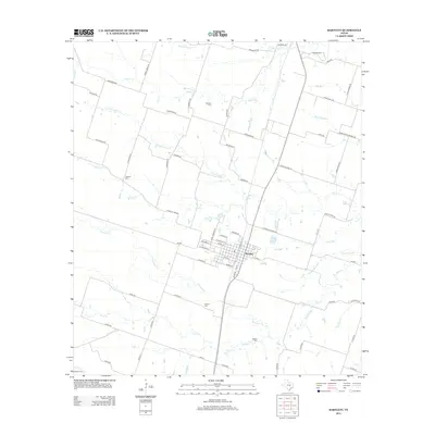
2012 Map of Bartlett
USGS Topo · Published 2012About this map
Bartlett serves as the central hub of this agricultural landscape, situated at the crossroads of FM-487 and local routes like W Clark St and E Evie St. The town's grid is dense with residential streets such as N Bowie St and W Bell St, reflecting its role as a local center for commerce and community. Surrounding the town, the land is partitioned into large tracts defined by a network of drainage systems, including the southward-flowing Middle Darrs Cr and the prominent Donahoe Cr. For researchers, the distribution of rural cemeteries like Stockton Cem, Roucker Cem, and Jackson Cem offers significant genealogical value, marking old family homesteads and early settlements scattered across the blackland prairie. The transportation network is highly developed, featuring distinctive thoroughfares such as Lutheran Church Rd and Pecan School Rd, which hint at the community's social history.
Find a feature on this map
69 named features on this map. Tap any name to fly to it.
Don’t see what you’re looking for? This feature index may not catch every label — zoom into the map to look around manually.
Map Details
Editions of this 2012 Bartlett Map
This is the sole edition of this map. No revisions or reprints were ever made.
Other maps of this area

1885 · Taylor
USGS Topo · 1:125,000

1887 · Taylor
USGS Topo · 1:125,000

1893 · Georgetown
USGS Topo · 1:125,000

1894 · Taylor
USGS Topo · 1:125,000

1928 · Round Rock
USGS Topo · 1:62,500

1949 · Round Rock
USGS Topo · 1:62,500

1951 · Round Rock
USGS Topo · 1:62,500

1954 · Austin
USGS Topo · 1:250,000

1963 · Friendship
USGS Topo · 1:24,000
1963 · Davilla
USGS Topo · 1:24,000