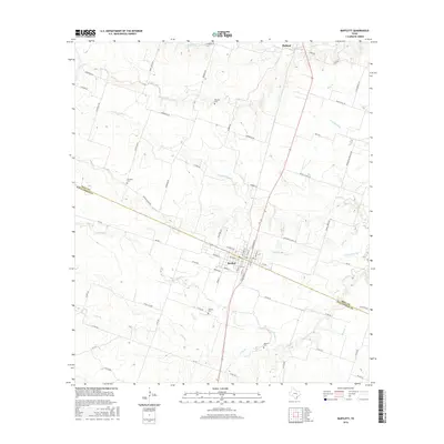
2016 Map of Bartlett
USGS Topo · Published 2016About this map
Bartlett straddles the county line dividing Bell Co and Williamson Co, serving as a central hub for the surrounding agricultural plains. The landscape is defined by a dense network of seasonal watercourses and creek branches, including Donahoe Cr, Indian Cr, and several forks of Darrs Cr that drain the blackland soil. The street grid of the town is detailed with names like W Bell St and Arnold Dr, while the outlying areas are connected by numerous farm roads.
Find a feature on this map
71 named features on this map. Tap any name to fly to it.
Don’t see what you’re looking for? This feature index may not catch every label — zoom into the map to look around manually.
Map Details
Editions of this 2016 Bartlett Map
This is the sole edition of this map. No revisions or reprints were ever made.
Other maps of this area

1885 · Taylor
USGS Topo · 1:125,000

1887 · Taylor
USGS Topo · 1:125,000

1893 · Georgetown
USGS Topo · 1:125,000

1894 · Taylor
USGS Topo · 1:125,000

1928 · Round Rock
USGS Topo · 1:62,500

1949 · Round Rock
USGS Topo · 1:62,500

1951 · Round Rock
USGS Topo · 1:62,500

1954 · Austin
USGS Topo · 1:250,000

1963 · Friendship
USGS Topo · 1:24,000
1963 · Davilla
USGS Topo · 1:24,000