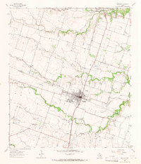
1964 Map of Bartlett
USGS Topo · Published 1966About this map
The town of Bartlett straddles the boundary of Bell and Williamson Counties, serving as a central hub for the surrounding agricultural prairie in the mid-1960s. The Missouri Kansas Texas railroad cuts a straight north-south line through the community, connecting it to Holland to the north. This rail corridor is the primary industrial axis for the region, passing by a Water Tank and a Sewage Disposal plant that supported the local population.
Find a feature on this map
24 named features on this map. Tap any name to fly to it.
Don’t see what you’re looking for? This feature index may not catch every label — zoom into the map to look around manually.
Map Details
Editions of this 1964 Bartlett Map
2 editions found
Other maps of this area

1885 · Taylor
USGS Topo · 1:125,000

1887 · Taylor
USGS Topo · 1:125,000

1893 · Georgetown
USGS Topo · 1:125,000

1894 · Taylor
USGS Topo · 1:125,000

1928 · Round Rock
USGS Topo · 1:62,500

1949 · Round Rock
USGS Topo · 1:62,500

1951 · Round Rock
USGS Topo · 1:62,500

1954 · Austin
USGS Topo · 1:250,000

1963 · Friendship
USGS Topo · 1:24,000
1963 · Davilla
USGS Topo · 1:24,000