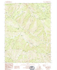
1989 Map of Bartlett Springs
USGS Topo · Published 1994About this map
Bartlett Springs and Newman Springs anchor this mountainous section of the Mendocino National Forest, where high ridgelines and creek drainages define the landscape. The terrain is dominated by prominent elevations such as Ruppert Ridge and Pacific Ridge, which served as a lookout point at the Pacific Ridge FS Station. The intricate waterway network includes Cache Creek, Bartlett Creek, and the North Fork Cache Creek, punctuated by small upland features like Tule Pond and Royal Spring.
Find a feature on this map
59 named features on this map. Tap any name to fly to it.
Don’t see what you’re looking for? This feature index may not catch every label — zoom into the map to look around manually.
Map Details
Editions of this 1989 Bartlett Springs Map
3 editions found
Other maps of this area

1922 · Hullville
USGS Topo · 1:62,500

1924 · Bartlett Springs
USGS Topo · 1:62,500

1938 · Lakeport
USGS Topo · 1:62,500

1942 · Bartlett Springs
USGS Topo · 1:62,500

1944 · Bartlett Springs
USGS Topo · 1:62,500

1951 · Lake Pillsbury
USGS Topo · 1:62,500

1951 · Lakeport
USGS Topo · 1:62,500

1951 · Stonyford
USGS Topo · 1:62,500

1957 · Ukiah
USGS Topo · 1:250,000

1958 · Clearlake Oaks
USGS Topo · 1:24,000