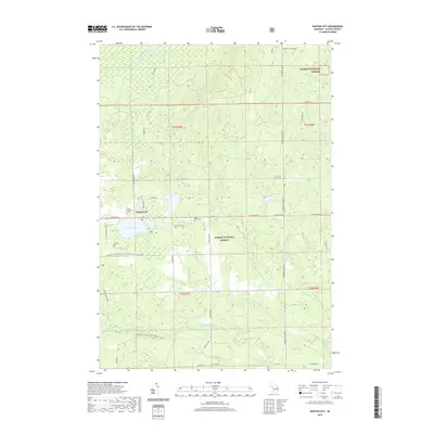
2019 Map of Barton City
USGS Topo · Published 2019About this map
Barton City serves as the central hub of this Alcona County landscape, situated just north of the expansive Jewell Lake. The area is defined by a dense network of forest service trails and local roads that weave through the Huron National Forest, reflecting the region's deep connection to timber and recreation. Waterways like the West Branch River and W Br Pine River drain the terrain, which is dotted with smaller water bodies such as Potter Lake and Maynard Lake. Local heritage is anchored by sites like the Trinity Lutheran Cem and Maple Ridge Cem, which provide specific points of interest for genealogical research in this part of northeastern Michigan. The presence of the Alcona ATV Trail and various snowmobile routes highlights the modern recreational utility of these public lands.
Find a feature on this map
42 named features on this map. Tap any name to fly to it.
Don’t see what you’re looking for? This feature index may not catch every label — zoom into the map to look around manually.
Map Details
Editions of this 2019 Barton City Map
This is the sole edition of this map. No revisions or reprints were ever made.
Other maps of this area

1954 · Tawas City
USGS Topo · 1:250,000

1958 · Tawas City
USGS Topo · 1:250,000

1959 · Glennie
USGS Topo · 1:62,500

1959 · Harrisville
USGS Topo · 1:62,500

1971 · Spruce
USGS Topo · 1:24,000

1972 · Hubbard Lake
USGS Topo · 1:24,000

1972 · Hubbard Lake SW
USGS Topo · 1:24,000

1983 · Hubbard Lake
USGS Topo · 1:100,000
1989 · Barton City
USGS Topo · 1:24,000

1989 · Mikado
USGS Topo · 1:24,000