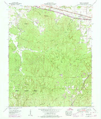
1953 Map of Barton
USGS Topo · Published 1974About this map
The Southern Railway and Lee Highway corridor serves as the primary artery for this portion of Colbert County, connecting the settlements of Cherokee and Barton. North of the tracks, a drive-in theater reflects mid-century social life, while the landscape south of the corridor rises into the prominent Mills Mountain Ridge. This area is characterized by numerous hollows, such as Stillhouse Hollow and Bugg Mill Hollow, which suggest a history of localized water-powered industry and traditional Appalachian settlement patterns.
Find a feature on this map
61 named features on this map. Tap any name to fly to it.
Don’t see what you’re looking for? This feature index may not catch every label — zoom into the map to look around manually.
Map Details
Editions of this 1953 Barton Map
4 editions found
Other maps of this area

1911 · Iuka
USGS Topo · 1:48,000

1914 · Iuka
USGS Topo · 1:62,500

1924 · Gravelly Springs
USGS Topo · 1:48,000

1925 · Barton
USGS Topo · 1:62,500

1926 · Barton
USGS Topo · 1:48,000

1926 · Gravelly Springs
USGS Topo · 1:62,500

1929 · Barton
USGS Topo · 1:62,500

1935 · Cherokee
USGS Topo · 1:24,000

1935 · Pleasant Site
USGS Topo · 1:24,000

1936 · Margerum
USGS Topo · 1:24,000