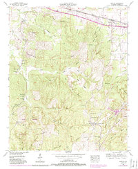
1953 Map of Barton
USGS Topo · Published 1989About this map
Cherokee and Barton anchor the northern landscape of this mid-century survey, situated along the corridor of the Southern Railway and the Lee Highway. This region of Alabama is defined by a dense network of hollows and ridges, where family names are etched into the geography at sites like Watkins Cemetery and McCullough Cemetery. The map illustrates a rural economy transitioning from early industry to managed wilderness, evidenced by several quarries and the expansive Thomas Wildlife Management Area in the southwest.
Find a feature on this map
59 named features on this map. Tap any name to fly to it.
Don’t see what you’re looking for? This feature index may not catch every label — zoom into the map to look around manually.
Map Details
Editions of this 1953 Barton Map
4 editions found
Other maps of this area

1911 · Iuka
USGS Topo · 1:48,000

1914 · Iuka
USGS Topo · 1:62,500

1924 · Gravelly Springs
USGS Topo · 1:48,000

1925 · Barton
USGS Topo · 1:62,500

1926 · Barton
USGS Topo · 1:48,000

1926 · Gravelly Springs
USGS Topo · 1:62,500

1929 · Barton
USGS Topo · 1:62,500

1935 · Cherokee
USGS Topo · 1:24,000

1935 · Pleasant Site
USGS Topo · 1:24,000

1936 · Margerum
USGS Topo · 1:24,000