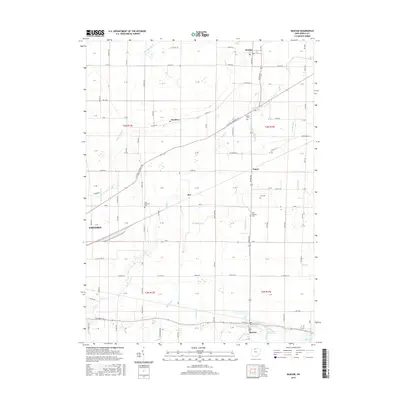
2016 Map of Bascom
USGS Topo · Published 2016About this map
Bascom and the surrounding township lands of Seneca County are defined by a complex network of agricultural drainage and small rural settlements in this 2016 survey. The terrain is etched with numerous named waterways, including Wolf Creek, Muskellunge Creek, and the Stultz Henry Ditch, reflecting a landscape managed for farming. Small communities such as Kansas, Amsden, and Iler serve as local hubs, connected by a rigid grid of country roads like Fostoria Fremont Road and Kansas Road.
Find a feature on this map
122 named features on this map. Tap any name to fly to it.
Don’t see what you’re looking for? This feature index may not catch every label — zoom into the map to look around manually.
Map Details
Editions of this 2016 Bascom Map
This is the sole edition of this map. No revisions or reprints were ever made.
Other maps of this area

1901 · Fostoria
USGS Topo · 1:62,500

1901 · Fremont
USGS Topo · 1:62,500

1901 · Elmore
USGS Topo · 1:62,500

1903 · Fremont
USGS Topo · 1:62,500

1903 · Fostoria
USGS Topo · 1:62,500

1903 · Elmore
USGS Topo · 1:62,500

1906 · Tiffin
USGS Topo · 1:62,500

1956 · Toledo
USGS Topo · 1:250,000

1958 · Fremont West
USGS Topo · 1:24,000
1958 · Bradner
USGS Topo · 1:24,000