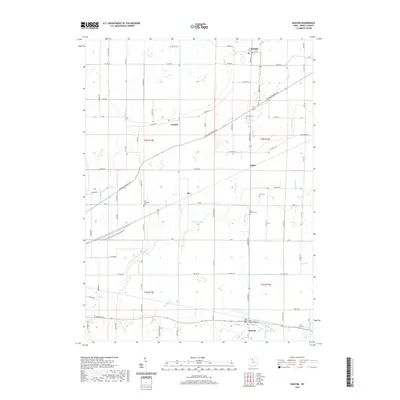
2019 Map of Bascom
USGS Topo · Published 2019About this map
The unincorporated community of Bascom anchors the southern portion of this Seneca County landscape, situated where local roads converge near the banks of E Br Wolf Cr. The region is defined by an extensive network of drainage features and small waterways, including Plum Run, Sherger Ditch, and Lynch Ditch, which support the surrounding agricultural fields. Small hamlets such as Kansas, Iler, and Angus are scattered throughout the territory, linked by historic routes like Fostoria Fremont Rd.
Find a feature on this map
87 named features on this map. Tap any name to fly to it.
Don’t see what you’re looking for? This feature index may not catch every label — zoom into the map to look around manually.
Map Details
Editions of this 2019 Bascom Map
This is the sole edition of this map. No revisions or reprints were ever made.
Other maps of this area

1901 · Fostoria
USGS Topo · 1:62,500

1901 · Fremont
USGS Topo · 1:62,500

1901 · Elmore
USGS Topo · 1:62,500

1903 · Fremont
USGS Topo · 1:62,500

1903 · Fostoria
USGS Topo · 1:62,500

1903 · Elmore
USGS Topo · 1:62,500

1906 · Tiffin
USGS Topo · 1:62,500

1956 · Toledo
USGS Topo · 1:250,000

1958 · Fremont West
USGS Topo · 1:24,000
1958 · Bradner
USGS Topo · 1:24,000